info@sgsinfotech.com


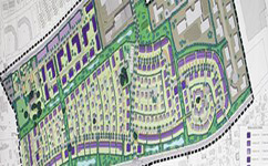
i-Infotech has immense experience in developing most effective solutions for urban development and planning. We have had the opportunity to work with development authorities in Bihar, Madhya Pradesh and Himachal Pradesh and Rajasthan under various projects for planning and GIS system development. i-Infotech has hand on experience in urban planning projects and provides the following services for Urban Planning.
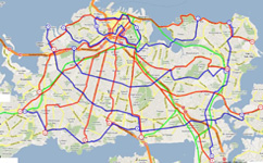
i-Infotech 's mapping portal provides information on a series of topics of interest for its citizens, visitors, researchers, and business community. The Geographic Information System (GIS) is technology used for the storage, retrieval, analysis, and display of geographic information. This information includes features or places within the city that have a location/geographic component, buildings, parcels, roads, or natural features including wetlands, woodlands and water bodies.
i-Infotech is an IT and Business Process Management (BPM) company that offers smart solutions to organizations across geographies and industry verticals and empowers them to respond quickly to changing market dynamics.