info@sgsinfotech.com


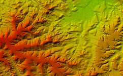
Lidar Mapping and surveying is used for forestry, flood risk mapping, oil & gas exploration surveys, power line transmission or pipeline corridor planning, construction surveys, real estate development, coastal zone mapping, wetlands and other restricted access areas, urban modeling, etc the use of airborne Light Detection And Ranging (LiDAR) technology offers rapid high resolution capture of surface elevation data suitable for a large range of applications
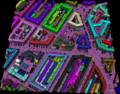
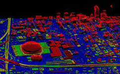
Classification of the data is done at the end of the processing cycle. This task processes the data points through an intensive filtering process, and various classes of points are separated. For example, vegetation data can be removed from the ground layer data, and it is also possible to separate buildings and power lines using customized filtering routines.
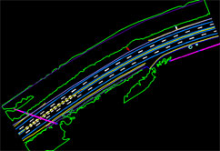
Vector Mapping is a representation of the Earth surface features in 3D manner and used for geospatial analysis and modelling. preparation of map by extracting vector or point information of railroads, buildings, hydrological features, vegetation, etc., as required by the user by different Symbols (trees, wells, poles, etc.,), Line types (rail, road, streams, etc.,) and Regions (buildings, tanks, forest, etc.,) with ID.
Digital vector mapping products are representations of major topographic map features with attributed point line and region/area data. Vector maps are digitized so that a geographical information system automatically can derive information from the vector features, making it possible to perform subsequent analysis (e.g. adjacency, proximity, and connectivity analyses).
Contours are commonly in vector formats (e.g., shape file, dxf) and derived from a reconstructed DEM of TIN . Contours are among the most commonly used representations for elevations. In i-Infotech Contours derived directly from LiDAR data are accurate but not “clean” and often require a level of interpolation, simplification, smoothing, or manual editing to achieve the intuitive product . In the process of cleaning and editing the vectors specification largely drives the definition of LiDAR data accuracy. This is a direct result of their widespread use for engineering and other common depictions. In many projects the data are collected to “support the generation of 2 ft contours” or similar statements required to achieve pleasing contours with the accuracy of the base LiDAR data; the widespread use and generation of contours continues to play a large role in defining the accuracy level of LiDAR data collections.
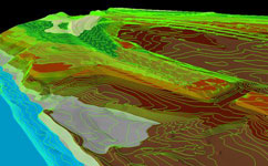
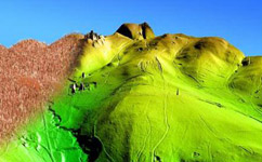
Our key functions include 3D visualization, 3D environment modelling, true 3D landscape reconstruction, visual reality and virtual reality integration, real time roaming with huge amounts of data.
We at i-Infotech realize "What you see is what you get!"
Our key functions include 3D visualization, 3D environment modeling, true 3D landscape reconstruction, visual reality and virtual reality integration, real time roaming with huge amounts of data. These 3D modelling techniques are wildly used in:
i-Infotech is an IT and Business Process Management (BPM) company that offers smart solutions to organizations across geographies and industry verticals and empowers them to respond quickly to changing market dynamics.