info@sgsinfotech.com


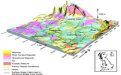
Geological mapping is done to show geological features. It provides geographical and physical data required for computational services for industries working world wide. We outsource geological mapping services with cost effective means. This data is produced to depict the shape, size, structure of the objects shown on geographical maps.
Our geologists offer a comprehensive range of onshore geological mapping services to the oil, gas and minerals industries, including structural and lithological interpretation and detailed fracture analysis utilizing various sources of satellite imagery and digital elevation models. At i-Infotech , all geological mapping information and other data sets are digitally managed and archives, using GIS maps and relational databases with high-quality map production.
Our Studies are performed within a GIS to facilitate integration of ancillary exploration data such as potential field, seismic and well data supplied by the customer.
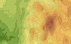
Contour are very important documents as the government and industrial mechanisms are increasingly employing the services of contour mapping systems to control floods, forest fires, real estate planning and development, and a host of other issues.
Contour analysis depicts the weather and oceanic conditions which portray the actual environmental situations which is used ecologists and weather forecast department to forecast the futuristic weather, they show the height of ground above Mean Sea Level (M.S.L.) in either feet or meter and can be drawn at any desired interval.
We at i-Infotech understand customer-collected data using specialized software to generate bathymetric maps. These accurate, geospatial models reveal the complex bathymetry and morphological charac-teristics and allow it to be graphically represented.Our staff also can use the resulting digital model to perform additional analysis.

i-Infotech is an IT and Business Process Management (BPM) company that offers smart solutions to organizations across geographies and industry verticals and empowers them to respond quickly to changing market dynamics.