info@sgsinfotech.com


The intent of the classification process is to categorize all pixels in a digital image into one of several land cover classes, or "themesThe objective of image classification is to identify and portray, as a unique gray level (or color), the features occurring in an image in terms of the object or type of land cover these features actually represent on the ground.
i-Infotech employs a variety of automated classification methodologies, supplemented by manual techniques, to generate image classifications. These methodologies consist of land-cover/land-use classifications and change-detection analyses, including binary change maps and thematic maps of land-cover changes. We work closely with you to define the classifications' thematic scheme and provide you with summary statistics, assessments of the resulting maps' accuracy, and poster-quality graphics for your use.
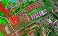
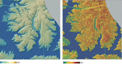
Image processing services is a type of sophisticated information processing in which both output and input are made of photo-like images and video frames. Services of image processing are used in many areas such as from satellite images creating weather maps.
i-Infotech is an adept at processing high-resolution imagery into quality raster data products. This involves removing distortions in the images to ensure that outputs are of the highest clarity, resolution, and color. Our service offerings include geo-referencing, ortho-rectification, mosaicing, color balancing, and cutting to specified output formats. i-Infotech is able to produce a seamless raster data product from multiple image tiles.
We have the ability to handle large volumes of images, automate most of the data management processes, and pass on the productivity gains to the client in terms of fast turn-around- time and competitively priced solutions.
i-Infotech is an IT and Business Process Management (BPM) company that offers smart solutions to organizations across geographies and industry verticals and empowers them to respond quickly to changing market dynamics.