info@sgsinfotech.com


i-Infotech provides complete solutions for all standard tasks in digital Photogrammetry services such as aerial triangulation, DEM / DTM generation, stereo compilation, topographic and Planimetric feature extraction, Orthophoto production, colour balancing, mosaicing and tile generation, pan sharpening, 3D terrain visualization, orthophotograph services and LiDAR data processing.
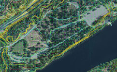
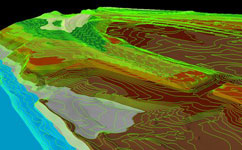
i-Infotech seamlessly integrates LiDAR data with other data sets, including orthophotos imagery. We can combine LiDAR with GIS data and other survey information to generate complex geomorphic-structure mapping products, advanced 3-D models/earthwork profiles, renderings of structures, and many additional high value mapping products.
The core of our competency lies in the expertise of providing geospatial solutions to the multifarious clientele in wide domain areas.
We integrate knowledge, technology, people, and business with geographic zones to develop innovative and potential services to local as well as global clients. Our services allow accurate and cost-effective data collection that proves to be an important input for planning and designing of photogrammetric and LiDAR projects.
Aerial Triangulation is the calculation of true ground co-ordinates, used as the base reference in Photogrammetry. Aerial Triangulation is the process of densifying and extending ground control through computational means. AT extends horizontal and vertical control from relatively few ground survey control points to each unknown ground point included in the solution. The supplemental control points are called tie points, and they are used to control subsequent photogrammetric mapping. Each stereo model is scaled and levelled using the adjusted coordinate values of the pass points located in the stereo model. i-Infotech offers complete softcopy aerial triangulation services, providing highly accurate control for the map production. Digital images are uploaded into softcopy workstations. The airborne GPS coordinates and the ground survey control points are used to control the triangulation solution.
The following documents would be required for executing the Aerial Triangulation process
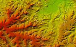
Digital elevation model (DEM) is a representation of the Earth's relief used for geospatial analysis and modelling. Elevation data are captured in the form of points with defined interval and the Breaklines.Digital elevation models are typically produced as an important basis for design and construction of infrastructure such as roads and railways.
In connection with excavations, open-cut mining and preparation of waste disposal sites, repeated measurement of digital elevation models can document alteration of the terrain and changes in volumes can be calculated.
Using the photogrammetric software a dense point cloud of heights is generated in multi images through automated elevation collection (correlation). The results are verified manually by using powerful editing tools. Elevation points on man-made structures or vegetation can be eliminated and gaps filled. As a final step the DTM is generated.
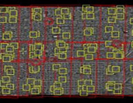
i-Infotech Pvt. Limited has state of the art photogrammetric mapping facilities. Before to start a vector compilation project, an accurate estimation is done regarding the time, man power and project duration. To analyze the project requirements and expectations of the client, we review the project based on standards and specifications that are documented in compliance with an ISO 9001:2000 certified process, to ensure a smooth production flow.
As per the project specifications and client requirements, various kinds of features (Buildings, Roads, Man Holes, Drains, Light poles, Streams, Fences, and Parking etc.) are captured on Digital Photogrammetric Workstations using scanned/digital images. i-Infotech Pvt. Ltd. has successfully executed many projects that involve New Mapping (large scale) as well as updation work with high accuracy.
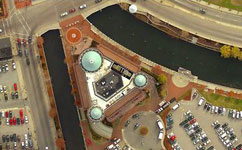
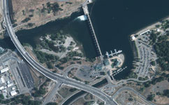
An orthophotograph is an aerial colour photograph geometrically and geographically corrected to be superimposed on a plan. The production of orthophotograph consists of correcting the distortions of the exposures caused by ground surface relief.
Digital Orthophoto are used as maps, for visual identification, also with combination of other mapping products like DTM and contours.
We at i-Infotech generate a digital Orthophoto that most closely achieves the resolution of the continuous tone, original aerial image, we apply a variety of image enhancement and edge sharpening routines using special Image Processing techniques.
The process involves colour / contrast matching and feathering techniques to ensure a virtually seamless mosaic. Many images can be mosaicked and resampled to produce an overview image file to supplement the original orthoimages. Accuracy is measured by comparing the rectified position of ground control point to the true coordinates of the point.
At i-Infotech Pvt. Ltd., we create Orthophoto with pixel size of 10cm, 20cm, 40cm. We work on RGB and Infra Red Imagery also.
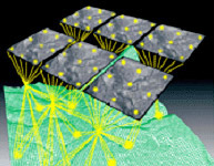
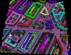
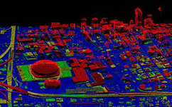
Lidar Mapping and surveying is used for forestry, flood risk mapping, oil & gas exploration surveys, power line transmission or pipeline corridor planning, construction surveys, real estate development, coastal zone mapping, wetlands and other restricted access areas, urban modeling, etc the use of airborne Light Detection And Ranging (LiDAR) technology offers rapid high resolution capture of surface elevation data suitable for a large range of applications
Classification of the data is done at the end of the processing cycle. This task processes the data points through an intensive filtering process, and various classes of points are separated. For example, vegetation data can be removed from the ground layer data, and it is also possible to separate buildings and power lines using customized filtering routines.
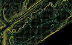
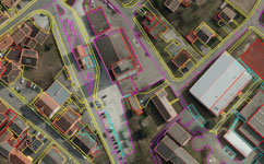
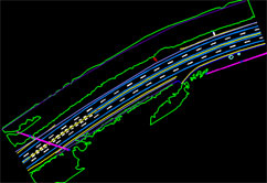
Vector Mapping is a representation of the Earth surface features in 3D manner and used for geospatial analysis and modelling. preparation of map by extracting vector or point information of railroads, buildings, hydrological features, vegetation, etc., as required by the user by different Symbols (trees, wells, poles, etc.,), Line types (rail, road, streams, etc.,) and Regions (buildings, tanks, forest, etc.,) with ID.
Digital vector mapping products are representations of major topographic map features with attributed point line and region/area data. Vector maps are digitized so that a geographical information system automatically can derive information from the vector features, making it possible to perform subsequent analysis (e.g. adjacency, proximity, and connectivity analyses).
Contours are commonly in vector formats (e.g., shape file, dxf) and derived from a reconstructed DEM of TIN . Contours are among the most commonly used representations for elevations. In i-Infotech Contours derived directly from LiDAR data are accurate but not “clean” and often require a level of interpolation, simplification, smoothing, or manual editing to achieve the intuitive product . In the process of cleaning and editing the vectors specification largely drives the definition of LiDAR data accuracy. This is a direct result of their widespread use for engineering and other common depictions. In many projects the data are collected to “support the generation of 2 ft contours” or similar statements required to achieve pleasing contours with the accuracy of the base LiDAR data; the widespread use and generation of contours continues to play a large role in defining the accuracy level of LiDAR data collections.
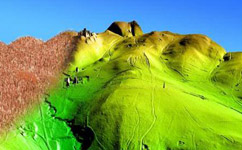
Our key functions include 3D visualization, 3D environment modelling, true 3D landscape reconstruction, visual reality and virtual reality integration, real time roaming with huge amounts of data.
We at i-Infotech realize "What you see is what you get!"
Our key functions include 3D visualization, 3D environment modeling, true 3D landscape reconstruction, visual reality and virtual reality integration, real time roaming with huge amounts of data. These 3D modelling techniques are wildly used in:
i-Infotech is an IT and Business Process Management (BPM) company that offers smart solutions to organizations across geographies and industry verticals and empowers them to respond quickly to changing market dynamics.