info@sgsinfotech.com


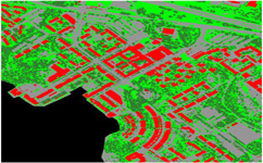
The Land cover reflects the biophysical state of the earth's surface and immediate subsurface, thus embracing the soil material, vegetation, and water. Land use refers to man's activities on land which are directly related to the land. Land use and land cover are dynamic. Changes may involve the nature or intensity of change but may also include spatial (forest abatement at village level, or for a large-scale agro industrial plant), and time aspects. Land use/ Land cover changes also involve the modification, either direct or indirect, of natural habitats and their impact on the ecology of the area.
Land Use Land Cover features have been precisely captured through on-screen visual interpretation and digitally on fused very high resolution (0.60 m, Quick Bird) and medium to coarse resolution (LISS IV, LISS III) satellite imagery. Provision of such maps helps town planners in effective and best possible utilization of its resources besides providing a comprehensive view of the total area i-Infotech has qualified remote sensing professionals with experiences in different domains.
The team has developed several processes and algorithm to semi-automate the process of image classification especially to generate Land-use/Land-cover data. It has the experience in creation of Land use/Land cover data using various resolutions ranging from 0.5m to as coarse as 250m.
By using remotely sensed imagery and semi-automated classification methods, i-Infotech provides cost-effective and accurate means to derive land resource information and maintain its currency into the future.
i-Infotech is an IT and Business Process Management (BPM) company that offers smart solutions to organizations across geographies and industry verticals and empowers them to respond quickly to changing market dynamics.