info@sgsinfotech.com


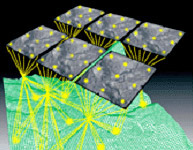
Aerial Triangulation is the calculation of true ground co-ordinates, used as the base reference in Photogrammetry. Aerial Triangulation is the process of densifying and extending ground control through computational means. AT extends horizontal and vertical control from relatively few ground survey control points to each unknown ground point included in the solution. The supplemental control points are called tie points, and they are used to control subsequent photogrammetric mapping. Each stereo model is scaled and levelled using the adjusted coordinate values of the pass points located in the stereo model. i-Infotech offers complete softcopy aerial triangulation services, providing highly accurate control for the map production. Digital images are uploaded into softcopy workstations. The airborne GPS coordinates and the ground survey control points are used to control the triangulation solution.
The following documents would be required for executing the Aerial Triangulation process
i-Infotech is an IT and Business Process Management (BPM) company that offers smart solutions to organizations across geographies and industry verticals and empowers them to respond quickly to changing market dynamics.