info@sgsinfotech.com

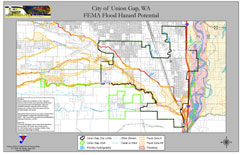
Flood Mapping shows the map of the area which could get flooded if the water level rises to a particular elevation. A flood map is a risk assessment tool used to help determine the different flooding risks in a community
Flooding can happen anywhere, but certain areas are especially prone to serious flooding. To help communities understand their risk, flood maps (Flood Insurance Rate Maps, FIRMs) have been created by FEMA to show the locations of high-risk areas, moderate-to-low risk areas, and undetermined-risk areas.
A Risk Report and Flood Determination is perfect for anyone who has been notified by their lender or insurer that they are required to purchase flood insurance with little or no evidence why, and find they are not in a FEMA designated high-risk flood zone.
Flood Determination is a unique product specifically developed for commercial and construction lending. We make it possible for you to receive large-tract determinations with building-specific information to ensure that you know which buildings fall within the special flood hazard area. We provide solutions designed to help you make decisions early in the loan process. We use advanced technology to streamline the entire process. We also utilize our strong industry background to better understand the unique needs associated with your day-to-day workload. We make the flood zone determination, certification and map-tracking process smooth and efficient. Our focus is to provide customers with the highest automated hit rates, fast turn times, impeccable accuracy and exceptional customer service.
All Flood Determination (certifications) is based on the currently effective FEMA Flood Insurance Rate Map (FIRM). To obtain a fast and accurate response, we process the Flood Determination through our comprehensive database of digital maps, parcel boundaries, geocoding software, street maps, tax maps, plats, aerial and satellite photos and previously determined properties.


i-Infotech is an IT and Business Process Management (BPM) company that offers smart solutions to organizations across geographies and industry verticals and empowers them to respond quickly to changing market dynamics.