info@sgsinfotech.com


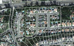
Parcel mapping services is one of the most important aspects of Geographic Information System (GIS). Strict requirements are needed for services in parcel mapping for the parcel map must be bereft of any error.
Parcel Mapping is the process in which land parcels are created. These maps comprise of polygons which are created from the base map, which shows the details of the ownership of the properties and related information. The base maps are the cadastral maps showing each individual plots in different sub divisions. The land parcels are the fundamental data layer on which different data are referenced.
i-Infotech have professionally skilled team to execute parcel mapping and related projects with precision that fulfill client's requirements in unbeatable time frame and competitive cost.
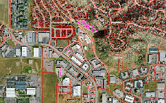
Full Re-Mapping from Deed/Plat using COGO is the most intensive cadastral product i-Infotech offers. All property ownership documents (deeds, hardcopy maps, right of way plans, subdivision plans etc.,) in the County are optically scanned and indexed. i-Infotech uses this information to build a county-wide cadastral layer, one parcel at a time, using coordinate geometry, or COGO.
We have good experience and capacity to plot parcel from legal description.
All survey calculations are performed with a COGO program, running inside of AutoCAD creating an independent database of the coordinate point numbers. Data is subsequently converted to ArcView for GIS Analysis.
Following process is adopted for COGO mapping
Digitization – Parcel maps are converted from paper to digital format utilizing a combination of digitization, scanning and Coordinate Geometry (COGO) entry from official survey plats.
Conflation – Our best-fit conflation processes improves the accuracy of the parcel maps by rectifying to an accurate base map or ortho photography base.
Parcel Attribution / Linking – Utilizing an exact copy of the official real estate database, our process links each parcel to the Meta data in the geo-database format with no manual re-entry of data.
Maintenance Services – Maps can be kept up to date utilizing our maintenance services via Coordinate Geometry (COGO) entry of survey plats.
Parcel Maintenance System – Our custom parcel maintenance solution allows the user to maintain the parcel mapping in-house and provides all functionality required for COGO entry of new plats, attribution of new parcels, addition of new annotation and all map symbols, and provides easy access for parcel map production.
i-Infotech is an IT and Business Process Management (BPM) company that offers smart solutions to organizations across geographies and industry verticals and empowers them to respond quickly to changing market dynamics.