info@sgsinfotech.com


Topographic mapping services are the most widely used category among all maps. In topographic maps, the contour lines are used to show the elevation and shape of the land. This feature distinguishes topographic maps from all the other kinds of maps.
Topographic Maps are essential instruments for a variety of monitoring and planning activities. compatibility of topographic mapping services. Even the government departments opt for digital mapping information for their networks.
i-Infotech Services experts are working on large-scale thematic and topographic mapping projects for clients around the globe. Projects can be reliably designed to time constraints and budget lines, and i-Infotech services usually relies on in-country mapping expertise in the course of such projects.
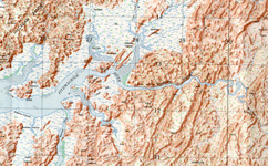
Topographic mapping has been an integral part of a country's cartography.i-Infotech produce Improved information to deliver new maps. World wide acceptance of computer produced maps has accelerated the use of computer compatibility of topographic mapping services. Even the government departments opt for digital mapping information for their networks.
The Cadastral maps are a comprehensive register of the detailed real property of an area. This includes the precise location, dimensions, and other geographical classifications of properties, and individual parcels of land.
Cadastral mapping is done from hard copies of the administrative maps, which specifies the details of each plot, roads, railway lines, water bodies, vegetation, etc. Cadastral mapping leads to effective management of public land records. The cadastral maps are linked with a backend database which has details of each plot, and their attributes.
i-Infotech undertakes large scale cadastral mapping projects which includes
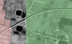
Cadastral maps also show additional details, such as survey district names, unique identifying numbers for parcels, certificate of title numbers, positions of existing structures, section or lot numbers and their respective areas, adjoining and adjacent street names, selected boundary dimensions and references to prior maps.
i-Infotech is an IT and Business Process Management (BPM) company that offers smart solutions to organizations across geographies and industry verticals and empowers them to respond quickly to changing market dynamics.