info@sgsinfotech.com


Reputed for the quality solutions provided for telecommunication, government organizations, as well as utility, i-Infotech brings forth its specialized services in the field of geospatial (GIS) and remote sensing technology.
With a dedicated department for this area, our Geospatial Division stands distinct in terms of the technical resources and expertise employed. Our team of GIS professionals is well versed diverse aspects and current developments in this field, and is experienced in the deployment of GIS and remote sensing technology. As a part of the comprehensive services offered by our Geospatial Division, i-Infotech proudly presents a range of solutions related to application development, as well as data management. We also offer our customized consulting services, which are designed to assist our clients with various stages of project development, such as planning, executing, as well as offering further support related to GIS technology and data.
We make extensive use of remote sensing technology for various projects. Our experts also help clients in meeting specific mapping requirements including agriculture, soil mapping, forestry, mapping land use and cover, city planning, archaeological investigations, military observations, geo-morphological surveying, by making use of satellite images taken from different sensors and color bands. Our company aims to deliver well-designed business solutions, by making use of sophisticated geospatial capabilities and technology.
i-Infotech offers comprehensive solutions globally. These include solutions and services for creating and updating digital geospatial databases.
One of i-Infotech 's key strengths is its ability to convert large volumes of paper maps and drawings to digital format with quick turn-around times. i-Infotech are capable for managing complex conversion projects, which require creation of data from multiple sources of varying scales, vintages, and quality.
These sources could be a combination of topographic maps, CAD drawings, satellite imagery, aerial photographs or observations from field surveys. i-Infotech 's integrated processes for conversion include scanning, digitizing (heads-up and tablet), data layering, fitting/geopositioning, statistical batch quality assurance/quality control, and translation into final output.
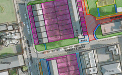
Parcel mapping services is one of the most important aspects of Geographic Information System (GIS). Strict requirements are needed for services in parcel mapping for the parcel map must be bereft of any error.
Parcel Mapping is the process in which land parcels are created. These maps comprise of polygons which are created from the base map, which shows the details of the ownership of the properties and related information. The base maps are the cadastral maps showing each individual plots in different sub divisions. The land parcels are the fundamental data layer on which different data are referenced.
i-Infotech have professionally skilled team to execute parcel mapping and related projects with precision that fulfill client's requirements in unbeatable time frame and competitive cost.
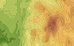
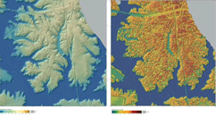
Topographic mapping services are the most widely used category among all maps. In topographic maps, the contour lines are used to show the elevation and shape of the land. This feature distinguishes topographic maps from all the other kinds of maps.
Topographic Maps are essential instruments for a variety of monitoring and planning activities. compatibility of topographic mapping services. Even the government departments opt for digital mapping information for their networks.
i-Infotech Services experts are working on large-scale thematic and topographic mapping projects for clients around the globe. Projects can be reliably designed to time constraints and budget lines, and i-Infotech services usually relies on in-country mapping expertise in the course of such projects.
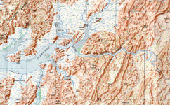
Topographic mapping has been an integral part of a country's cartography.i-Infotech produce Improved information to deliver new maps. World wide acceptance of computer produced maps has accelerated the use of computer compatibility of topographic mapping services. Even the government departments opt for digital mapping information for their networks.
The Cadastral maps are a comprehensive register of the detailed real property of an area. This includes the precise location, dimensions, and other geographical classifications of properties, and individual parcels of land.
Cadastral mapping is done from hard copies of the administrative maps, which specifies the details of each plot, roads, railway lines, water bodies, vegetation, etc. Cadastral mapping leads to effective management of public land records. The cadastral maps are linked with a backend database which has details of each plot, and their attributes.
i-Infotech undertakes large scale cadastral mapping projects which includes
Cadastral maps also show additional details, such as survey district names, unique identifying numbers for parcels, certificate of title numbers, positions of existing structures, section or lot numbers and their respective areas, adjoining and adjacent street names, selected boundary dimensions and references to prior maps.
Contour are very important documents as the government and industrial mechanisms are increasingly employing the services of contour mapping systems to control floods, forest fires, real estate planning and development, and a host of other issues.
Contour analysis depicts the weather and oceanic conditions which portray the actual environmental situations which is used ecologists and weather forecast department to forecast the futuristic weather, they show the height of ground above Mean Sea Level (M.S.L.) in either feet or meter and can be drawn at any desired interval.
We at i-Infotech understand customer-collected data using specialized software to generate bathymetric maps. These accurate, geospatial models reveal the complex bathymetry and morphological charac-teristics and allow it to be graphically represented.Our staff also can use the resulting digital model to perform additional analysis.
Land base is a vector mapping product that depicts core land cover to a level of detail and extent. Key features of the landscape such as on road location, surface condition, road centerline position, and a detail on the multitude of highway signage related to transportation routes and provide classification down to individual property level. The new land cover product is a vector map produced using the latest digital aerial imagery and object based classification technology .We at i-Infotech Use genuine software to develop the land cover classifications, land-based GPS positioning been used with marginal success as a mapping data acquisition tool to accurately position Planimetric features in open, unobstructed areas.
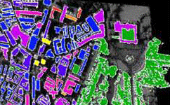
Our Land Base is designed as a framework, for used within a GIS system, to allow specific spatial queries-what percentage of this area is covered by trees-as well as allow the addition of further detailed classifications. These maps are made as per the clients Data model and specifications and delivered as per specific formats (Tab, Shape, Small World, etc.). We have been providing these services to our existing clients for last several years with a full quality satisfaction and cost effectiveness.
Image processing services is a type of sophisticated information processing in which both output and input are made of photo-like images and video frames. Services of image processing are used in many areas such as from satellite images creating weather maps.
i-Infotech is an adept at processing high-resolution imagery into quality raster data products. This involves removing distortions in the images to ensure that outputs are of the highest clarity, resolution, and color. Our service offerings include geo-referencing, ortho-rectification, mosaicing, color balancing, and cutting to specified output formats. i-Infotech is able to produce a seamless raster data product from multiple image tiles.
We have the ability to handle large volumes of images, automate most of the data management processes, and pass on the productivity gains to the client in terms of fast turn-around- time and competitively priced solutions.
The intent of the classification process is to categorize all pixels in a digital image into one of several land cover classes, or "themesThe objective of image classification is to identify and portray, as a unique gray level (or color), the features occurring in an image in terms of the object or type of land cover these features actually represent on the ground.
i-Infotech employs a variety of automated classification methodologies, supplemented by manual techniques, to generate image classifications. These methodologies consist of land-cover/land-use classifications and change-detection analyses, including binary change maps and thematic maps of land-cover changes. We work closely with you to define the classifications' thematic scheme and provide you with summary statistics, assessments of the resulting maps' accuracy, and poster-quality graphics for your use.
We are an organization made up of skilled and dedicated individuals who collectively provide comprehensive and quality surveying services while maintaining high professional and principled standards. We feel that rural citizens and communities should be serviced by professionals who are truly interested and understand the unique needs of small communities and their citizens. i-Infotech takes great pride in doing their job efficiently.
i-Infotech approaches our projects with a "team effort." We involve all personnel necessary to complete the project in a timely manner and produce a quality product for our client. Though we may have several projects going through our office at any given time, we are geared up to handle additional projects and are equipped to begin work on your needs right away.

Utility providers confront various challenges while planning, designing and implementing their operations. Natural catastrophes, sabotages and other industrial accidents can cause critical disruptions to the distribution and supply of Utilities to millions of people. GIS-based data management systems and solutions developed by i-Infotech team help the Utilities providers to leverage operational efficiency, provide superior services and manage cost effectively.
i-Infotech utility mapping service include many segments including the land base creation, system modelling, circuit map creation, raster to vector map conversion and work order updates. We work with high-end software such as AutoCAD, Microstation for utility mapping. Our highly skilled professionals blend the technologies of digital mapping from variety of sources including aerial photographs, satellite images, GPS field data and existing maps to create the GIS database.
We specialize in utility mapping which consists of many different services including full system digitization, system modelling, land base creation, revisions, work order updates, circuit map creation and Paper to CAD map conversion.
Effective operations, supply, and protection of the environment requires accurate canonic data and we at i-Infotech guarantee to offer you the same through our utility mapping services. We believe in the philosophy of working together with clients to deliver projects on time and on budget. Over the past decade, we have built a reputation as one of the leading utility mapping service providers. Cost reductions and safety enhancements can be realized during the design and construction phases of a project by comprehensive mapping of all underground infrastructures with geophysical technology.
Broadening power supply landscape has posted challenges in resource planning, implementation of projects and maintenance of quality services. To overcome these challenges, a comprehensive enterprise resource planning clubbed with utility mapping services is essential. i-Infotech `s GIS utility mapping services helps you to plan, control, and co-ordinate critical areas in power supply, such as outage management, geographical database planning, distribution management, supply line management, installations management, etc. i-Infotech `s infotech ingenious GIS solutions and services help the power utility providers to plan pervasive solutions to manage their resources effectively.
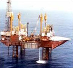
Oil and Gas utility providers are responsible to customers, government and other regulatory bodies for the safe distribution and supply of oil and gas. They often face challenges of leakages and supply disruptions. Our GIS utility mapping services helps the oil and gas suppliers to tackle these challenges and effectively manage the whole system of oil and gas supply pipelines. Our pioneering activities in GIS development enhance your pipeline management system and provide the best solutions for your operations management.We have a team of experts working on complex GIS Utility Mapping functions, with experience in handling large volumes of enterprise data in formats such as CAD, paper, any digitized formats, portable storage devices, Pipeline Open Data Standard (PODS) or Pipeline Data Model or combination of these, in any data base or in any other form.
Electricity providers are responsible to customers, government and other regulatory bodies for the safe distribution and supply. They often face challenges of supply disruptions. Our GIS utility mapping services helps them to tackle these challenges and effectively manage the whole system of electricity networks and linkages. Our pioneering activities in GIS development enhance your electricity distribution management system and provide the best solutions for your operations management.
We have a team of experts working on complex GIS Utility Mapping functions, with experience in handling large volumes of enterprise data in formats such as CAD, paper, any digitized formats, and portable storage devices.

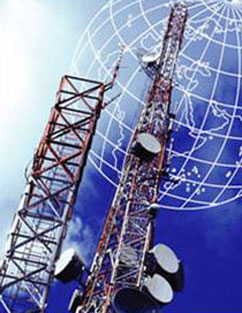
Telecom industry has seen an upswing with the beginning of Mobile phone technology. With the expansion of network providers and innovative technological sophistication, Telecom service providers need to sustain in the highly competitive market with uninterrupted service and faster communication systems. To implement faster technology, substantial understanding of the geography of system installations and service networks is necessary. i-Infotech utility mapping services is one of the world's leading utility mapping service provider. We have executed some of the world's largest utility mapping projects. We have developed a highly generic utility mapping production system. The generic system is flexible enough to accommodate complex business rules that differentiate one project from the other. The result is the creation of a highly optimized production flow line for creating an as-built Network Information Systems.
Water management is critical in a world faced with fierce water scarcity problems. Increasing urbanization has aggravated the risk of water logging in cities and townships, which in turn interrupts normal living of its citizens. In addition, famine and water scarcity in the agricultural landscapes call for proper water supply to these areas. Therefore, water resource management has become essential in all corners.i-Infotech helps the water and sewage management organizations to efficiently design and implement quality utility services. Water supply resources and the pipeline network can be planned, designed and established meticulously using our GIS utility mapping services. Our services so far has helped many public and private conglomerates to provide highly capable water management systems.

Geo-referencing is the process of scaling, rotating, translating and deskewing the image to match a particular size and position.
Geo-reference is the process of defining something existence in physical space or in other words establishing its location in terms coordinate systems representing earth defined through projection systems. It is used when establishing the relation between raster or vector images by determining the spatial location of the geographical features. This procedure is mandatory for data modeling in the field of geographic information systems (GIS). When data from different sources or time periods (like time series satellite images) need to be combined and then used in a GIS application, (e.g. for change detection, assess damages after a natural disaster etc.), it becomes essential to have a common referencing system. One can geo-reference a set of points, lines, polygons, images, or 3D structures (e.g. shape file geo-referencing). This is brought about by using various geo-referencing techniques. Most geo-referencing tasks are undertaken either because the user wants to produce a new map or because they want to link two or more different data sets to the same geographic locations or mapping new features or updates in an existing data.
A crucial element of any mapping project is registering a map with the correct real world coordinates. This procedure is called geo-referencing. If the maps are not geo-referenced, no other information can be displayed over or positioned under the map coverage.
Depending on the source materials and the specifications of the project, maps can be registered to either a coordinate system or to another base map such as a digital ortho photo.
Vector data can be geo-referenced (or rubber sheeted) to real world coordinates. Vector data can be either rubber sheeted to match existing base maps or the data may be projected into a specific coordinate system. i-Infotech offers expert geo-referencing services which include geo-rectification and accurate mapping services for a wide range of industry domains.
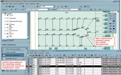
Full Re-Mapping from Deed/Plat using COGO is the most intensive cadastral product i-Infotech offers. All property ownership documents (deeds, hardcopy maps, right of way plans, subdivision plans etc.,) in the County are optically scanned and indexed. i-Infotech uses this information to build a county-wide cadastral layer, one parcel at a time, using coordinate geometry, or COGO.
We have good experience and capacity to plot parcel from legal description.
All survey calculations are performed with a COGO program, running inside of AutoCAD creating an independent database of the coordinate point numbers. Data is subsequently converted to ArcView for GIS Analysis.
Following process is adopted for COGO mapping
Digitization – Parcel maps are converted from paper to digital format utilizing a combination of digitization, scanning and Coordinate Geometry (COGO) entry from official survey plats.
Conflation – Our best-fit conflation processes improves the accuracy of the parcel maps by rectifying to an accurate base map or ortho photography base.
Parcel Attribution / Linking – Utilizing an exact copy of the official real estate database, our process links each parcel to the Meta data in the geo-database format with no manual re-entry of data.
Maintenance Services – Maps can be kept up to date utilizing our maintenance services via Coordinate Geometry (COGO) entry of survey plats.
Parcel Maintenance System – Our custom parcel maintenance solution allows the user to maintain the parcel mapping in-house and provides all functionality required for COGO entry of new plats, attribution of new parcels, addition of new annotation and all map symbols, and provides easy access for parcel map production.
A crucial element of any mapping project is registering a map with the correct real world coordinates. This procedure is called geo-referencing. If the maps are not geo-referenced, no other information can be displayed over or positioned under the map coverage.
Depending on the source materials and the specifications of the project, maps can be registered to either a coordinate system or to another base map such as a digital ortho photo.
Vector data can be geo-referenced (or rubber sheeted) to real world coordinates. Vector data can be either rubber sheeted to match existing base maps or the data may be projected into a specific coordinate system. i-Infotech offers expert geo-referencing services which include geo-rectification and accurate mapping services for a wide range of industry domains.

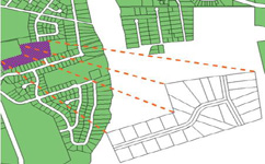
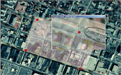
i-Infotech 's mapping portal provides information on a series of topics of interest for its citizens, visitors, researchers, and business community. The Geographic Information System (GIS) is technology used for the storage, retrieval, analysis, and display of geographic information. This information includes features or places within the city that have a location/geographic component, buildings, parcels, roads, or natural features including wetlands, woodlands and water bodies.
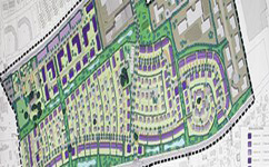
i-Infotech has immense experience in developing most effective solutions for urban development and planning. We have had the opportunity to work with development authorities in Bihar, Madhya Pradesh and Himachal Pradesh and Rajasthan under various projects for planning and GIS system development. i-Infotech has hand on experience in urban planning projects and provides the following services for Urban Planning.
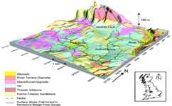
Geological mapping is done to show geological features. It provides geographical and physical data required for computational services for industries working world wide. We outsource geological mapping services with cost effective means. This data is produced to depict the shape, size, structure of the objects shown on geographical maps.
Our geologists offer a comprehensive range of onshore geological mapping services to the oil, gas and minerals industries, including structural and lithological interpretation and detailed fracture analysis utilizing various sources of satellite imagery and digital elevation models. At i-Infotech , all geological mapping information and other data sets are digitally managed and archives, using GIS maps and relational databases with high-quality map production.
Our Studies are performed within a GIS to facilitate integration of ancillary exploration data such as potential field, seismic and well data supplied by the customer.

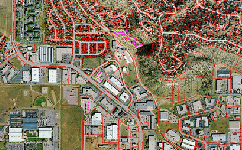
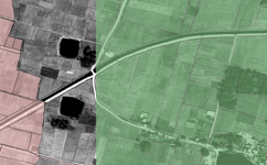
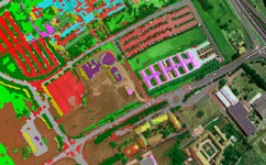
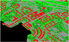
The Land cover reflects the biophysical state of the earth's surface and immediate subsurface, thus embracing the soil material, vegetation, and water. Land use refers to man's activities on land which are directly related to the land. Land use and land cover are dynamic. Changes may involve the nature or intensity of change but may also include spatial (forest abatement at village level, or for a large-scale agro industrial plant), and time aspects. Land use/ Land cover changes also involve the modification, either direct or indirect, of natural habitats and their impact on the ecology of the area.
Land Use Land Cover features have been precisely captured through on-screen visual interpretation and digitally on fused very high resolution (0.60 m, Quick Bird) and medium to coarse resolution (LISS IV, LISS III) satellite imagery. Provision of such maps helps town planners in effective and best possible utilization of its resources besides providing a comprehensive view of the total area i-Infotech has qualified remote sensing professionals with experiences in different domains.
The team has developed several processes and algorithm to semi-automate the process of image classification especially to generate Land-use/Land-cover data. It has the experience in creation of Land use/Land cover data using various resolutions ranging from 0.5m to as coarse as 250m.
By using remotely sensed imagery and semi-automated classification methods, i-Infotech provides cost-effective and accurate means to derive land resource information and maintain its currency into the future.
i-Infotech is an IT and Business Process Management (BPM) company that offers smart solutions to organizations across geographies and industry verticals and empowers them to respond quickly to changing market dynamics.