info@sgsinfotech.com


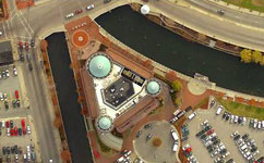
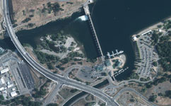
An orthophotograph is an aerial colour photograph geometrically and geographically corrected to be superimposed on a plan. The production of orthophotograph consists of correcting the distortions of the exposures caused by ground surface relief.
Digital Orthophoto are used as maps, for visual identification, also with combination of other mapping products like DTM and contours.
We at i-Infotech generate a digital Orthophoto that most closely achieves the resolution of the continuous tone, original aerial image, we apply a variety of image enhancement and edge sharpening routines using special Image Processing techniques.
The process involves colour / contrast matching and feathering techniques to ensure a virtually seamless mosaic. Many images can be mosaicked and resampled to produce an overview image file to supplement the original orthoimages. Accuracy is measured by comparing the rectified position of ground control point to the true coordinates of the point.
At i-Infotech Pvt. Ltd., we create Orthophoto with pixel size of 10cm, 20cm, 40cm. We work on RGB and Infra Red Imagery also.
i-Infotech is an IT and Business Process Management (BPM) company that offers smart solutions to organizations across geographies and industry verticals and empowers them to respond quickly to changing market dynamics.