info@sgsinfotech.com


Our Geospatial Division consists of a unique blend of highly specialized GIS professionals that have significant experience in the deployment of GIS and remote sensing technology and come from diverse areas within the GIS industry and community. Within our Geospatial Division, i-Infotech offers a full range of products and services in the areas of data management, application development, and consulting to help our clients successfully plan, implement, and support GIS technology and data
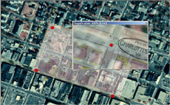
Geo-referencing is the process of scaling, rotating, translating and deskewing the image to match a particular size and position.
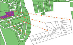
Geo-reference is the process of defining something existence in physical space or in other words establishing its location in terms coordinate systems representing earth defined through projection systems. It is used when establishing the relation between raster or vector images by determining the spatial location of the geographical features. This procedure is mandatory for data modeling in the field of geographic information systems (GIS). When data from different sources or time periods (like time series satellite images) need to be combined and then used in a GIS application, (e.g. for change detection, assess damages after a natural disaster etc.), it becomes essential to have a common referencing system. One can geo-reference a set of points, lines, polygons, images, or 3D structures (e.g. shape file geo-referencing). This is brought about by using various geo-referencing techniques. Most geo-referencing tasks are undertaken either because the user wants to produce a new map or because they want to link two or more different data sets to the same geographic locations or mapping new features or updates in an existing data.
A crucial element of any mapping project is registering a map with the correct real world coordinates. This procedure is called geo-referencing. If the maps are not geo-referenced, no other information can be displayed over or positioned under the map coverage.
Depending on the source materials and the specifications of the project, maps can be registered to either a coordinate system or to another base map such as a digital ortho photo.
Vector data can be geo-referenced (or rubber sheeted) to real world coordinates. Vector data can be either rubber sheeted to match existing base maps or the data may be projected into a specific coordinate system. i-Infotech offers expert geo-referencing services which include geo-rectification and accurate mapping services for a wide range of industry domains.
i-Infotech is an IT and Business Process Management (BPM) company that offers smart solutions to organizations across geographies and industry verticals and empowers them to respond quickly to changing market dynamics.