info@sgsinfotech.com


Digital elevation model (DEM) is a representation of the Earth's relief used for geospatial analysis and modelling. Elevation data are captured in the form of points with defined interval and the Breaklines.Digital elevation models are typically produced as an important basis for design and construction of infrastructure such as roads and railways.
In connection with excavations, open-cut mining and preparation of waste disposal sites, repeated measurement of digital elevation models can document alteration of the terrain and changes in volumes can be calculated.
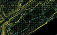
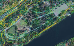
Using the photogrammetric software a dense point cloud of heights is generated in multi images through automated elevation collection (correlation). The results are verified manually by using powerful editing tools. Elevation points on man-made structures or vegetation can be eliminated and gaps filled. As a final step the DTM is generated.
i-Infotech is an IT and Business Process Management (BPM) company that offers smart solutions to organizations across geographies and industry verticals and empowers them to respond quickly to changing market dynamics.